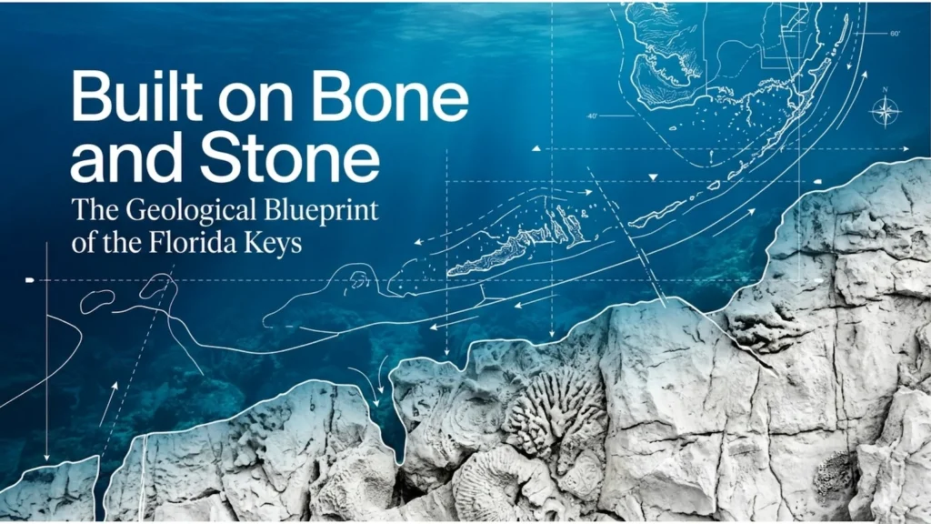
The Florida Keys may look like a string of sunlit islands, but beneath the roads, mangroves, and marinas lies a much older story, one shaped by coral reefs, oolitic shoals, falling seas, and dissolving limestone.
The Ancient Platform Underneath
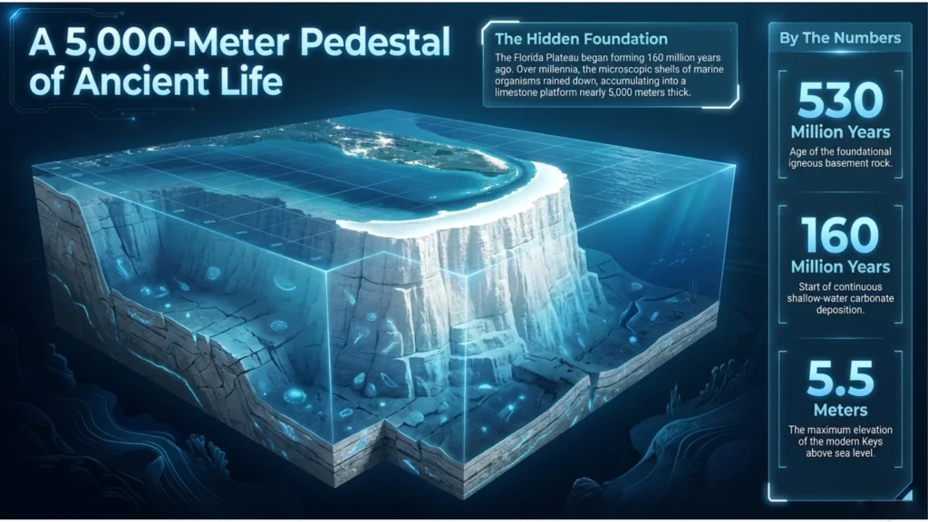
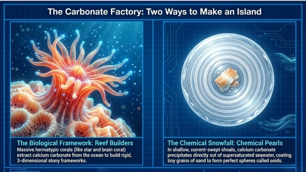
The story of the Keys starts long before the islands themselves. Beneath southern Florida lies a vast carbonate platform, built over immense stretches of time as marine organisms accumulated shell, skeleton, and lime-rich sediment layer by layer. The Florida Platform is thousands of feet thick, made largely of shallow-water carbonate deposits laid down over tens of millions of years.
The modern Keys are only the youngest exposed expression of that deeper structure. They are not isolated piles of sand. They are the visible edge of a much older limestone world, one that was built biologically in warm, shallow seas and later sculpted by changing sea levels. That is part of what gives the Keys their unusual mix of beauty and instability.
A Tale of Two Limestones
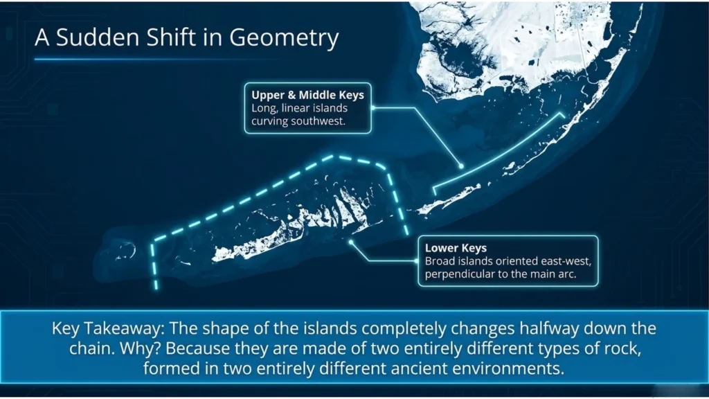
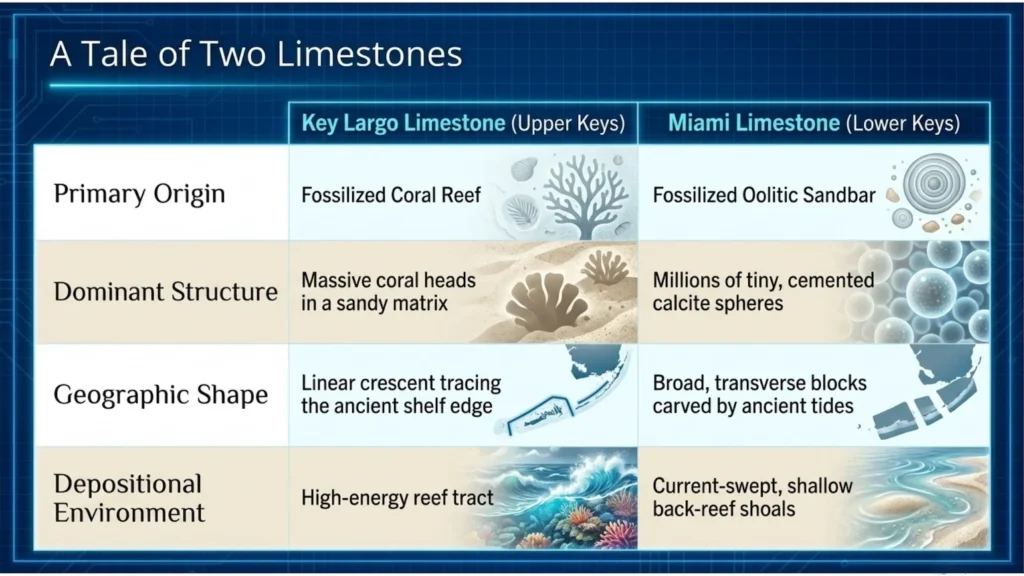
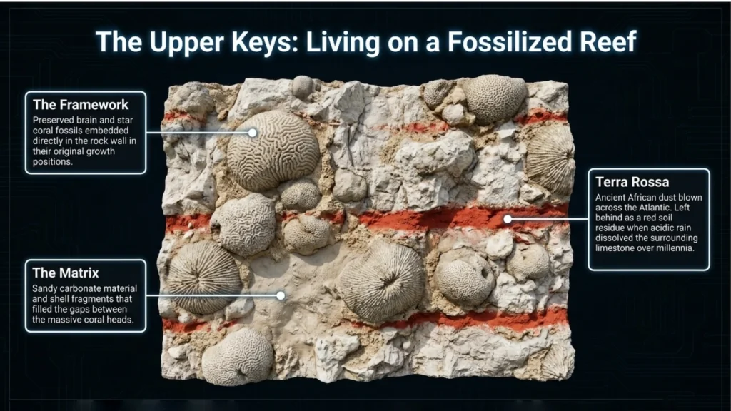
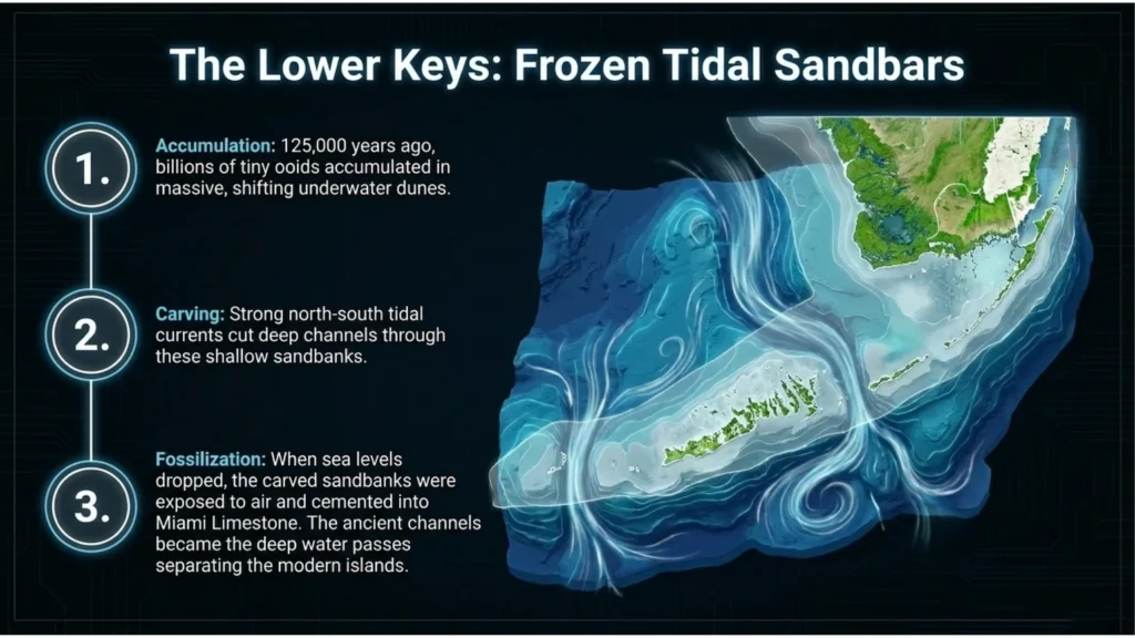
One of the most interesting facts about the Keys is that the island chain changes character halfway down. The long, linear upper and middle Keys are built largely from Key Largo Limestone, a fossil reef made of coral framework and reef-derived sediment. Farther southwest, the lower Keys are composed mainly of Miami Limestone, an oolitic rock formed from carbonate grains that accumulated in shallow, current-swept shoals.
That shift in rock type helps explain the shift in island shape. The upper Keys trace the old reef tract in a more linear arc, while the lower Keys tend to appear broader and more laterally segmented, reflecting the geometry of ancient tidal bars and oolitic shoals rather than a reef crest.
If you include the fossilized reef close-up, use it to make the point concrete: in places like Windley Key, you can still see corals preserved in the rock itself, locked in place like the skeleton of an ancient shoreline.
The Sea-Level Machine that Built the Keys
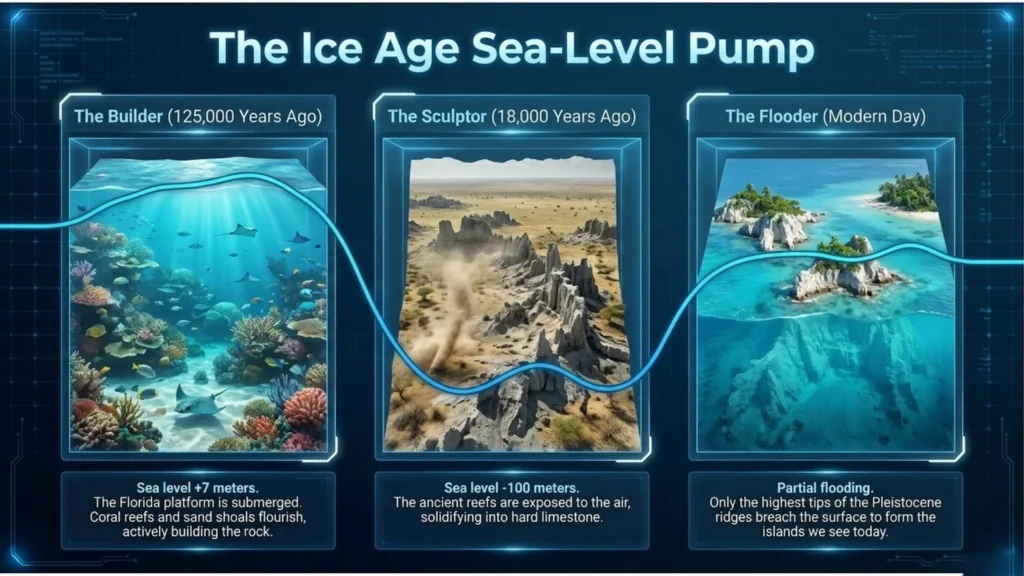
The Keys were shaped by a repeating geological rhythm: sea level rose, warm shallow seas encouraged carbonate production, and then sea level fell again, exposing those deposits to air. During the last interglacial, around 125,000 years ago, sea level stood higher than it does today, allowing reef growth and ooid shoals to build across the south Florida shelf. Later, during glacial lowstands, sea level dropped dramatically, exposing those carbonate bodies and allowing them to harden into limestone.
That is why the Keys are not simply piles of beach sand. In the upper and middle Keys, reef-building corals helped create a rigid three-dimensional framework that later lithified into Key Largo Limestone. In the lower Keys, carbonate grains called ooids accumulated in shallow, agitated water and later cemented into Miami Limestone. Two depositional systems, both driven by shallow tropical seas, ended up producing two different kinds of island bedrock.
Hollow Rock, Thin Soil, Fragile Ground
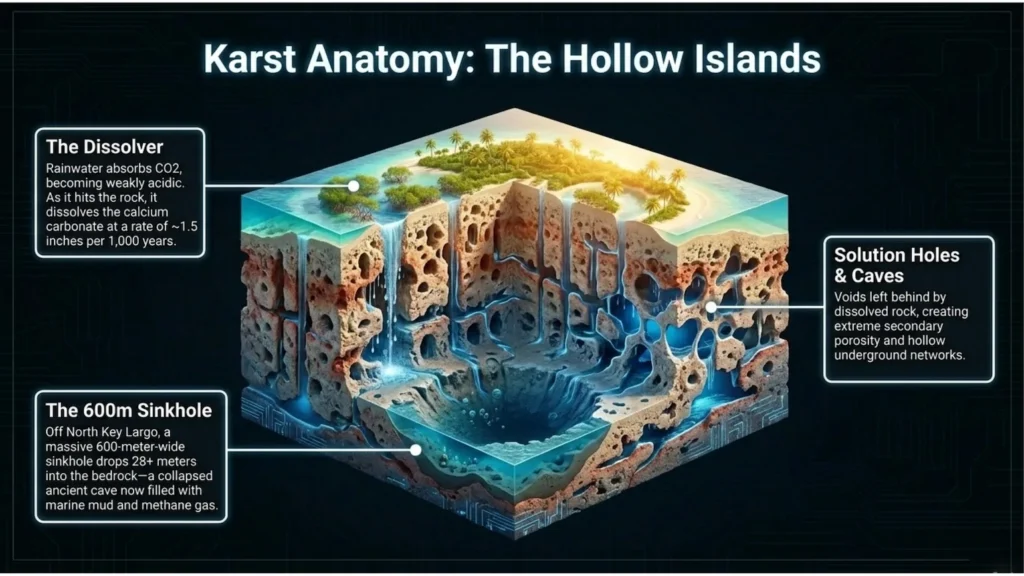
Once exposed to rain and air, limestone begins to change. Slightly acidic water can dissolve calcium carbonate over long periods, creating pits, cavities, solution holes, and larger karst features. That process helps explain why parts of the Keys are so porous and irregular beneath the surface. The islands may look solid from above, but much of their bedrock is riddled with openings and secondary porosity created by dissolution.
This matters because the modern Keys are ecologically rich but physically delicate. Thin soils, porous limestone, low elevation, and close contact with saltwater all shape how fresh water moves, how habitats form, and how vulnerable the islands are to erosion, flooding, and sea-level rise. The beauty of the Keys is inseparable from that fragility.
Final Takeaway
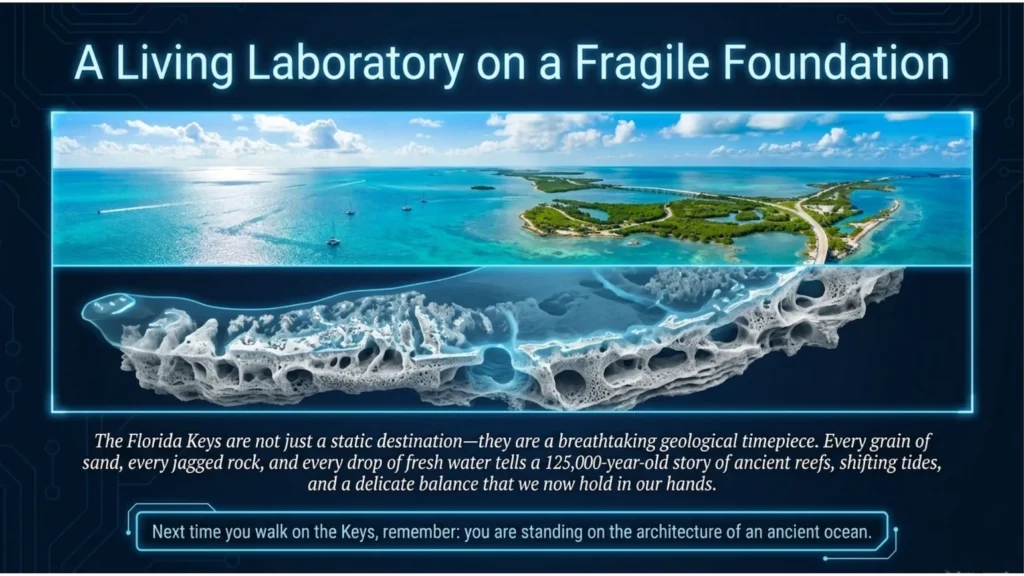
The Florida Keys are not just tropical islands. They are the exposed remains of ancient reefs and carbonate shoals, built in warm seas, exposed during glacial lowstands, and slowly altered by water ever since. To drive the Overseas Highway is to move across a fossil landscape, one part reef, one part sandbar, and entirely shaped by the long conversation between ocean, stone, and time.
References
Florida Fish and Wildlife Conservation Commission. (n.d.). Florida Keys. In K. R. Radabaugh & R. P. Moyer (Eds.), Coastal Habitat Integrated Mapping and Monitoring Program: Report for the State of Florida No. 2 (Chap. 9). https://archive.myfwc.com/archive/Research/Habitat/Coastal-Wetlands/CHIMMP/chimmp-v2-ch09.pdf
Halley, R. B., Vacher, H. L., & Shinn, E. A. (2004). Geology and hydrogeology of the Florida Keys. In Developments in Sedimentology (Vol. 54, pp. 217-248). Elsevier. https://doi.org/10.1016/S0070-4571(04)80027-X
Lidz, B. H., Reich, C. D., & Shinn, E. A. (2007). Regional geologic setting. In Systematic mapping of bedrock and habitats along the Florida Reef Tract: Central Key Largo to Halfmoon Shoal (Gulf of Mexico) (USGS Professional Paper 1751). U.S. Geological Survey. https://pubs.usgs.gov/pp/2007/1751/professional-paper/geologic-setting.html
Lidz, B. H., Reich, C. D., & Shinn, E. A. (2007).Overall setting and environment. In Systematic mapping of bedrock and habitats along the Florida Reef Tract: Central Key Largo to Halfmoon Shoal (Gulf of Mexico) (USGS Professional Paper 1751). U.S. Geological Survey. https://pubs.usgs.gov/pp/2007/1751/professional-paper/setting.html

